The Ljubljanica River
The Ljubljanica is a Slovenian river flowing through
the southern part of the Ljubljana Basin. It originates near Vrhnika.
After crossing the Ljubljana Marshes, it runs through the city of
Ljubljana and it flows as a right tributary into the Sava River at the
village of Podgrad.
The Ljubljanica is recharged by a number of karst
sinking streams in its catchment area. Its slow surface flow from the
springs near Vrhnika to the mouth to the Sava river has a length of 41
km, its total basin area (to its outflow into the river Sava) is 1884 km², of which 1100 km² is karstic. The karst hinterland of the springs
of the Ljubljanica includes waters of upstream valleys and plateaus that
are connected with underground streams. Some of these can be seen in
caves Golobina, Križna Cave, Karlovica, Zelške cave, Tkalca Cave,
Planinska Cave, Postojna Cave, Predjama, Logarček, Gradišnica and
Najdena Cave. The waterways include a large number of streams with
different names:
- Trbuhovica; it originates in the field Prezidsko polje in Croatia and disappears in the karstic field Babno polje
- Obrh; it runs through the Loka Valley where it disappears and reappears on the Cerknica Field
- Stržen; it disappears in the Cerknica Field, where the Cerkniščica also drains from the north, as well as the groundwater from the Bloke Plateau
- Rak; it flows through the Rakov Škocjan valley; in the cave Planinska jama it is joined by the river Pivka
- Pivka; it runs through the Pivka Basin and the Postojna Cave, in the cave Planinska jama it is joined by the Rak stream
- Unica is formed when the Pivka and Rak streams are joined in the cave Planinska jama; it flows on the field Planinsko polje
- Ljubljanica (originating near Vrhnika, it flows into the Sava at Podgrad)
- Logaščica stream, which partly involves the sinking systems of Rovte, Hotenjsko podolje and Logaško polje.
South of Vrhnika, these sinking streams are joined
underground by the rest aforementioned streams. At the edges of the
Ljubljana Marshes, the sinking waters from the Rakitna originate, at
first in Ponikve at Preserje and then in the karst spring at the town of
Kamnik pod Krimom. Although the Ljubljanica river basin belongs to the
Black Sea Basin, some streams from the Pivka Basin and the valley
Hotenjsko podolje flow underground into the rivers Timava, Vipava and
Idrijca, thus representing a bifurcation on the Black Sea/Adriatic
watershed.In Podgrad, there is a confluence of three rivers:
Ljubljanica, Sava and Kamniška Bistrica. Here, some 2000 years ago, the
Romans built a fortress (Sava Fluvia); at the same site at the time. the
stream Besnica flowed into the Sava River. In the 18th century, due to
inland navigation of large ships, the Sava and the Ljubljanica were
regulated, so the confluence was moved to Zalog (as mentioned in the
chronicles by Janez Vajkard Valvasor).
The Ljubljanica River, also known as the river of seven
names, is abundant in water, as the water is collected from 1884 km2.
The basin is mainly karstic; during floods the water builds up in the
karst fields and does not drain quickly, while during droughts, the
water percolates through the karst underground, which runs dry, while
the low flow rates are very low. For instance, the Sava river (with a
slightly larger basin area) at the confluence with the Ljubljanica, has
about four times higher flood flows and almost ten times higher low
flows.The Ljubljanica river is formed by many springs at the edges of
the Ljubljana Marshes and several major tributaries, such as the
Podlipščica, Borovniščica, Iška, Zidarjev graben, Iščica with the
Želimeljščica and Gradaščica. These rivers are the reason why the water
regime of the Ljubljanica is partly torrential. In its upper half, the
river undulates through the flat Ljubljana Marshes, keeping the flow
slow and steady. The water flows slowly in the several-metre-deep
channel, forming a water body with a volume of more than three million
cubic metres.
The bulk of the Marshes is underlain by an artesian
aquifer in which the pressures exceed the surface terrain and keep the
poorly consolidated surface layers of the lacustrine silt deposits
(called 'polžarica') in a delicate balance, which is maintained through
the gates on the Grubar Canal and on the Ljubljanica at the Ambrose
Square. In the Ljubljana Marshes, water is the element that is either
too abundant or too scarce, which is rather successfully regulated by
the barrier. Surface water and groundwater in the Ljubljana Marshes form
a complex and sensitive environment associated with subsidence, which in
places exceeds a centimetre per year. The subsidence of the marsh
surface is the reason why the drainage measures derived in the past did
not give the desired results, which largely prevented intensive
exploitation and settlement. To optimize the gates' operation, a complex
hydrological and hydraulic model will be built.
The Ljubljanica riverbed is one of the most important
archaeological sites in Slovenia. At the bottom of the river bed,
artefacts dating back to different periods are found, i.e. from
prehistoric to modern times. Due to its archaeological value, the river
Ljubljanica has been protected as a cultural monument since 2003.
The diverse hydrological water regime on the Ljubljana
Marshes enables the maintenance of a distinct ecological system with
high biodiversity protected by, and subject to, marshy lands. Part of
the Marshes is protected by Natura 2000. To improve the ecological
status in the Natura 2000 Ljubljana Marshes area, it is necessary to
ensure the passage on the Ljubljanica for endangered fish species,
particularly for Danube Salmon, Danube Roach and Striped Chub.
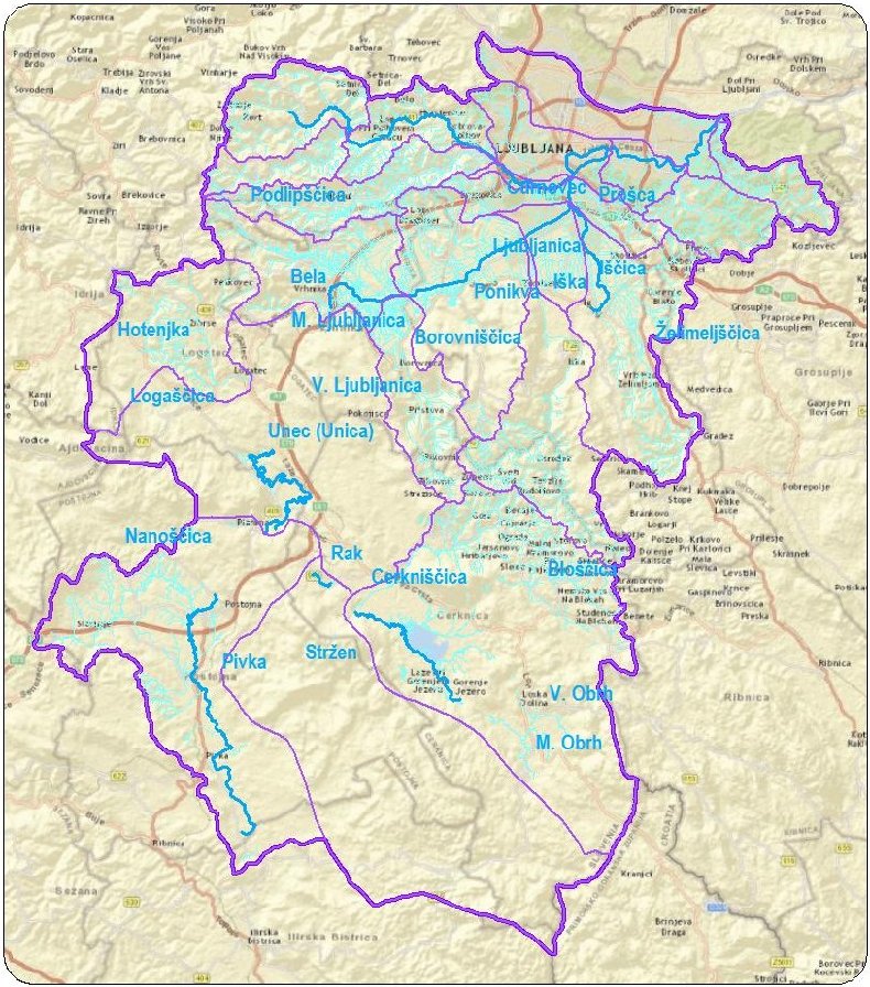
Map of Watershed of Ljubljanica river